Check out five free reading, science cards to printout. This is considered Montessori Culture or traditional Environmental or Earth Science.
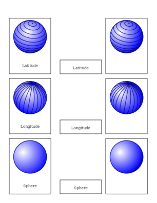
The Earth is a sphere shape.
The Earth is divided up into circles.
Circles measure where places are located on the Earth.
Here are two types of methods that use circles to measure the Earth:
Longitude is used to measure positions east and west of the prime meridian. A line of longitude is called a meridian and it is a straight line along the circumference of the Earth from the north pole to the south pole. Each meridian is the same length. The prime meridian travels through Greenwich, England. This is considered 0 degrees longitude.
To measure positions of north and south, latitude is used. A line of latitude is called a parallel and is parallel to the equator. Parallels vary in length. The longest parallel is at the equator and the shortest are at the poles. The equator has latitude zero. The north pole has latitude 90 degrees north and the south pole has latitude 90 degrees south.
Here are three part cards for longitude and latitude .
A circle is divided into 360 parts. One of these 360 parts is called a degree . Each degree is divided into 60 minutes and each minute is divided into 60 seconds. Understanding how to read an analog clock makes this concept easier to understand.
To introduce longitude and latitude in a concrete way take a spherical balloon or ball and draw circles representing longitude and latitude on it. Use the three part cards as a pattern.
Here's a fun activity to practice coordinates
First start with this map and these cards . Match each card to the corresponding city on the map, note the longitude and latitude.
After students have mastered the map with labels use this map without labels . The student will have to use the coordinates and grid lines to match the label to the point.
Use this blank map and have the student mark the cities with a marker, pencil or push-pin. Use locations that spark your student's interest.
Similar Pages: