Newsletter (Geography) Latitude Longitude
Published on: June 28, 2008
Check out five free reading and science cards to print out. This is considered Montessori Culture or traditional Environmental or Earth Science.
The earth is a remarkable classroom all on its own, isn't it? When we invite children to explore geography through their hands and their hearts, we open up a world — quite literally — of wonder and discovery. Today's newsletter focuses on one of the most foundational concepts in earth science: latitude and longitude. And yes, we have free three-part cards to help bring this lesson to life at home or in your classroom.
Why Geography Matters in Montessori Education
In the Montessori curriculum, geography falls under the broad umbrella of Culture. This area encompasses everything from history and biology to art, music, and earth science. Maria Montessori believed that children are naturally curious about the world around them — where they live, what the earth looks like, and how everything is connected. Geography is not just about memorizing maps. It is about nurturing a child's sense of place, belonging, and respect for the planet we all share.
When we teach young learners about latitude and longitude, we are giving them a coordinate system for understanding the entire globe. These invisible lines that wrap around our earth help us locate any place on the planet. For a child, that realization is nothing short of magical.
Introducing Latitude and Longitude to Young Learners
So how do we make something as abstract as imaginary grid lines feel concrete and accessible? This is where the Montessori approach truly shines. We start with the sensorial — something the child can see and touch. A beautiful Montessori globe is one of the best starting points. Let the child run their fingers across the continents, feel the raised land masses, and notice the vast blue oceans.
Latitude lines run horizontally, parallel to the equator. You can teach children to remember this by saying "latitude is flat-itude." Longitude lines run vertically from pole to pole, like slices of an orange. Using a real orange or a ball with lines drawn on it can make this concept wonderfully tangible for little hands.
If you have been following along with our Lesson of the Day 30: Space and Geography, you already know how beautifully space science and geography complement each other.
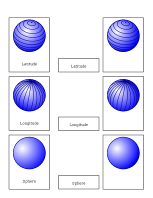
Three-Part Cards: A Montessori Staple
Three-part cards are one of the most versatile and beloved materials in any Montessori environment. Each set includes a control card (image with label), a picture card (image only), and a label card (text only). The child matches the picture to the label using the control card as a reference.
The latitude and longitude three-part cards featured in this newsletter introduce key terms such as equator, prime meridian, Northern Hemisphere, Southern Hemisphere, and more. Print them on cardstock, laminate them for durability, and they will last for years. Pair them with a world map puzzle for an even richer geography experience.
Connecting to the Broader Culture Curriculum
Once your child understands latitude and longitude, they are better prepared to explore topics like climate zones, ocean currents, and even plate tectonics. The earth becomes a story with interconnected chapters rather than isolated facts.
You might also enjoy our Montessori Newsletter 19, which offers additional printable resources and ideas for weaving culture studies into your daily rhythm.
Bringing It All Together
Whether you are a homeschooling parent setting up a geography shelf or a classroom guide looking for a quick printable extension, these latitude and longitude three-part cards are a wonderful addition to your materials. Download them, print them out, and watch your child's understanding of our beautiful planet grow one card at a time.
Happy exploring!